


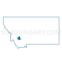
Precinct 20S, Silver Bow County, Montana
About
Outline

Summary
| Unique Area Identifier | 612279 |
| Name | Precinct 20S |
| County | Silver Bow County |
| State | Montana |
| Area (square miles) | 9.01 |
| Land Area (square miles) | 9.01 |
| Water Area (square miles) | 0.00 |
| % of Land Area | 100.00 |
| % of Water Area | 0.00 |
| Latitude of the Internal Point | 45.91542120 |
| Longtitude of the Internal Point | -112.54812220 |
Maps


Graphs
Select a template below for downloading or customizing gragh for Precinct 20S, Silver Bow County, Montana


Neighbors
Neighoring Voting District (by Name) Neighboring Voting District on the Map
- Precinct 19S, Silver Bow County, MT
- Precinct 20N, Silver Bow County, MT
- Precinct 26E, Silver Bow County, MT
- Precinct 9E, Silver Bow County, MT